Share your favorites on Show & Tell

1899 - Bureau of American Ethnology - California Map Showing Native Territories Pre-Settlement - 1898

In Paper > Maps > Show & Tell and Native American > Show & Tell.
Maps135 of 171Help with a Litho in USA postcard, please: looks to be a sort of travel log postcardCHINA WALL
7
Love it
0
Like it

rocker-sdrocker-sd loves this.
Vynil33rpmVynil33rpm loves this.
ho2cultchaho2cultcha loves this.
miKKoChristmas11miKKoChristmas11 loves this.
purpledogpurpledog loves this.
walksoftlywalksoftly loves this.
stefdesignstefdesign loves this.
See 5 more
Add to collection

    Please create an account, or Log in here

    If you don't have an account, create one here.


    Create a Show & TellReport as inappropriate


    Posted 13 years ago

    ho2cultcha
    (5053 items)

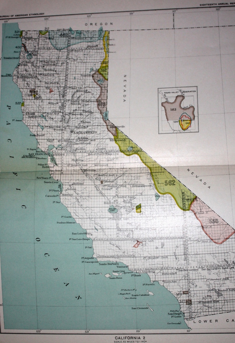
    This map is somewhat difficult to read, but very interesting to those of us in California. I bought this off Ebay a couple years ago. Has anyone ever seen this before? I'd love to find out more info on it or even share it w/ native people who might be interested.

    Unsolved Mystery

    Help us close this case. Add your knowledge below.

    logo
    Maps
    See all
    1867 Antique Alvin J. Johnsons Atlas NORTH AMERICA Hand-Colored Map Engraving NR
    1867 Antique Alvin J. Johnsons Atla...
    $132
    TRANSYLVANIA ROMANIA 1635ca BLAEU UNUSUAL ANTIQUE ORIGINAL COPPER ENGRAVED MAP
    TRANSYLVANIA ROMANIA 1635ca BLAEU U...
    $100
    AMERICAN CONTINENT CALIFORNIA AS AN ISLAND 1709 GONZALES UNUSUAL ANTIQUE MAP
    AMERICAN CONTINENT CALIFORNIA AS AN...
    $60
    1938 Hysterical Map Glacier Park & Blackfeet Reservation Montana Jolly Lindgren
    1938 Hysterical Map Glacier Park & ...
    $37
    logo
    1867 Antique Alvin J. Johnsons Atlas NORTH AMERICA Hand-Colored Map Engraving NR
    1867 Antique Alvin J. Johnsons Atla...
    $132
    See all

    Comments

    1. stefdesign stefdesign, 13 years ago
      Awesome find! I'm a Californian and would love to see this map up close. Reminds me of something found in the Southwest Museum in LA, which was founded by a man named Charles Loomis, who was somewhat an expert on California Indian culture 100 years or so ago.
    2. purpledog purpledog, 13 years ago
      This is so interesting! I love old maps and have a few. It's interesting to see how lands and lines grow and change. Thanks so much for posting this.
    3. ho2cultcha ho2cultcha, 8 years ago
      many years later, i finally see your comments stefdesign and purpledog! thank you for commenting!
    4. ho2cultcha ho2cultcha, 8 years ago
      Hi Thomas. i've shown the map to some California Indian friends before. I may make some copies of it to send to native friends around Hoopa or anywhere else they are interested. if you know of anyone, send them to me. pete@eastbaywilds.com

    Want to post a comment?

    Create an account or login in order to post a comment.